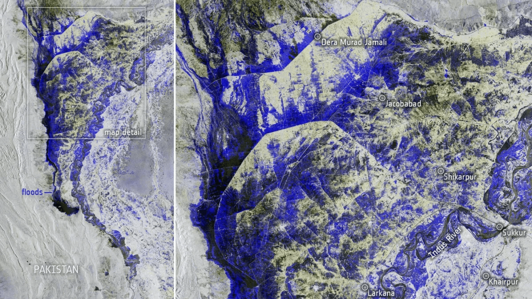
Pakistan is facing its worst floods in history. Heavy rains have been ravaging this country since June and have claimed over 1,300 lives. 50 million people had to move from their homes due to the floods. Images captured by the Copernicus Sentinel-1 show us the extent of the flooding, the European Space Agency said in a press release. While the media focuses mainly on heat waves in different parts of the world, Pakistan is hardly talked about. This country is plagued by a brutal amount of water. To get an idea of the effects of the floods, see the post below.
Pakistan's devastating floods:
– 1350 people killed
– 50M people displaced
– 900K livestock deaths
– 1M houses washed away
– 40+ reservoirs breached
– 220+ bridges collapsed
– 90% cropped damaged
– $10B loss to economy
– 1/3 country underwaterSource – PDMA / NDMA pic.twitter.com/TG6jnL8zZQ
— South Asia Index (@SouthAsiaIndex) August 29, 2022
Extreme weather in Pakistan
Extreme temperature fluctuations occur in this country, in the summer we can measure temperatures above 52°C in some places and in the winter the temperatures drop to -29°C in some places. Even in the past years, this region has faced floods, but they have never been here on such a scale. The current Prime Minister of Pakistan called these floods the worst in history. According to ESA data, Pakistan received ten times more rainfall than average this year. A large amount of rainfall has affected the largest river in Pakistan, which is called the Indus. The river became a lake that is over 100 km long and over 10 km wide. The satellite image shows the extent of the flood. The flooded part of the territory is marked in blue to black. This is mainly the western part of the country, which borders Afghanistan.

A humanitarian disaster
The floods affected one in seven Pakistanis and caused more than $10 billion in damage. It is a poor country, tens of millions of people have lost their homes, they have nowhere to live and there is also a lack of food. Because of the floods, infectious diseases are spreading rapidly here, and there has been a humanitarian disaster here.
Why did the floods happen here?
There is a reason for this extreme phenomenon. According to an Al Jazeera report, Pakistan experienced a heatwave in the month of May that resulted in the excessive melting of its mountain glaciers. A large amount of water had entered the soil, so that it was no longer able to absorb the additional water that came with the floods. The consequences of climate change are more visible this year than ever before, all over the world.
The future is already present, it's just distributed unevenly.
Climate breakdown is causing historic floods in Pakistan, and droughts in China and Europe.
We need immediate support for the Pakistani people, decarbonisation and funding for the frontline.pic.twitter.com/TyNgCjh8xE
— Jeremy Corbyn (@jeremycorbyn) August 30, 2022
ESA’s Copernicus Sentinel technology can track detailed rain and flood data. This data can help rescue workers reach critical areas. A large number of people are without food or shelter. They need quick help and medical supplies, otherwise the death toll may rise sharply.
Resources:
https://www.aljazeera.com/gallery/2022/7/14/photos-concerns-as-pakistan-glaciers-melt
https://www.esa.int/ESA_Multimedia/Images/2022/09/Pakistan_inundated
Image credit: ESA


